Project title
Water Quality & Data Visualization for RIWA-Maas
Project Overview
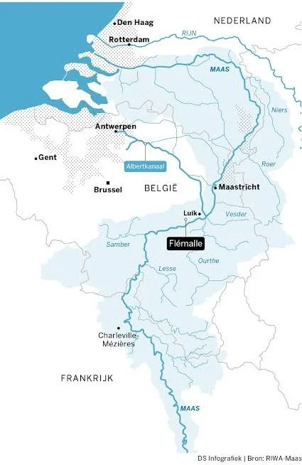
RIWA-Maas is the Meuse section of the Association of River Waterworks (RIWA), representing six drinking water companies in the Netherlands and Belgium that together supply drinking water to roughly seven million people, drawing close to 450 billion litres a year from the river Meuse. Their work centers on monitoring water quality, sharing knowledge among partners across the river basin, and influencing policy to keep the Meuse safe as a drinking water source.
My contribution
Support an environmental monitoring project focused on analyzing water quality data and identifying emerging contaminants within Dutch river systems. The project aimed to transform large and complex monitoring datasets into clear technical insights that support environmental assessment, reporting, and better decision-making for water management organizations.
On the data side, I worked through the water quality monitoring datasets in Excel and Power BI to surface trends in substances measured across the Meuse basin, and translated the results into charts, tables and infographics for the annual report. I also used GIS to determine the coordinates of measurement locations from address data, supporting the mapping of monitoring points across the river basin. The collaboration is ongoing, with GIS and data visualization work continuing alongside the support team in this project.
Technical Solutions Delivered

Interactive dashboards using Microsoft Power BI
Data analysis workflows in Python
Spatial visualization and mapping using QGIS
Environmental reporting support and data storytelling
Geographic analysis of monitoring networks and contaminant distribution
Project title
Water Quality Data Analysis: SMWK Monitoring Programme
Project Overview
SMWK (Schone Maaswaterketen, "Clean Meuse Water Chain") is a Dutch partnership running since 2015 that works to improve water quality in the Meuse (Maas) river and its catchment, focusing on microcontaminants, pharmaceutical residues, and similar substances that enter the water through wastewater. It covers the whole chain, from pollution source to tap water.
My contribution
In this project, I carried out an exploratory analysis of "bycatch" substances measured across the Meuse basin in 2023 and 2024:
Analyzed a large environmental monitoring dataset of 500+ chemical substances across 30 locations in the Meuse basin, turning a complex raw database into a focused set of actionable findings.
Designed a stepwise screening workflow to filter and prioritize substances based on detection frequency, spatial coverage, and data consistency, narrowing 500+ compounds down to 47 for detailed analysis.
Used Excel for data cleaning, structuring, and initial filtering of monitoring results across multiple organizations and laboratories.
Applied Python for data processing, detection-frequency calculations, statistical summaries, and temporal trend analysis, as well as generating charts and visualizations.
Built GIS-based spatial analyses and maps to visualize substance distribution, detection patterns, and exceedance hotspots across the monitoring network.
Compared measured concentrations against regulatory threshold values (KRW / RIVM standards) to flag substances and locations requiring further attention.
Prepared a comprehensive technical report documenting the methodology, results, and conclusions, with clear recommendations to support future monitoring and water quality management decisions.
Technical Solutions Delivered

Excel, Python & GIS: built an end-to-end data analysis pipeline from raw data to final visualization.
Python: automated detection-frequency calculations and statistical analysis.
GIS: created maps and heatmaps to visualize substance distribution and exceedance hotspots.
Excel: cleaned and standardized monitoring data from multiple organizations into a unified dataset.
Reporting: delivered a technical report with clear visualizations and actionable recommendations.

Project title
Understanding Harbour Seal Population Dynamics in the Dutch Wadden Sea
Project Overview
A two-year applied research project (2024–2026) led by Van Hall Larenstein University of Applied Sciences, funded by Regieorgaan SIA (NWO) and linked to the Dutch Ministry of Agriculture, Nature and Food Quality. The Wadden Sea's harbour seal population has stabilized and then declined since 2022, even as more pups are born each year, and the causes remain unknown. The project brings together a national consortium (including Utrecht University, Rijkswaterstaat, the Common Wadden Sea Secretariat, Ecomare, and Pieterburen) to investigate the drivers behind these trends, structured around four themes: mapping governance and data, identifying population mechanisms, improving monitoring, and advising on governance.
My contribution
As part of the broader Wadden Sea harbour seal project, my MSc thesis focused on the data and analytical question at its core: what actually drives the seal population, and how can that understanding support better management? My main contribution was designing and carrying out the food web data analysis.
I built a multi-source dataset, including environmental, biological, and anthropogenic factors. The environmental layers were derived from MODIS satellite imagery and processed in ArcGIS using composite-band, cell-statistics, and zonal-statistics tools to convert raw satellite data into usable time series for the study area.
Using R / RStudio, I then ran correlation analysis, linear modeling, time-series and bivariate trend analysis, and non-metric multidimensional scaling (NMDS) to explore the structure of the food web.
Beyond the data work, I also designed and facilitated a multi-stakeholder workshop (using the DAPSI(W)R(M) systems framework) and analyzed a real Dutch policy transition, bringing the quantitative findings together with the governance and human dimensions of seal management.
Technical Solutions Delivered
R / RStudio: statistical analysis: correlation, linear modeling, time-series analysis, and NMDS.
ArcGIS: processing MODIS satellite data into environmental layers (composite-band, cell- and zonal-statistics).
MODIS satellite data: sea surface temperature, chlorophyll-a, and PAR
Multi-source data integration: combining seal counts, prey fish, bivalves, and fisheries landings (CBS) into one 2003–2023 dataset.
DAPSI(W)R(M) framework: frameworks for stakeholder engagement and policy analysis.
Project title
Europe Today, Special Issue on Living Labs
Project Overview
This article was published in a special issue of Europe Today dedicated to Living Labs. In these real-world, collaborative environments, students, residents, businesses, and policymakers work together to tackle complex challenges. Living Labs are central to Van Hall Larenstein's MSc River Delta Development programme, where students take on practical delta-management problems (flooding, subsidence, salinization) hands-on with local stakeholders. The special issue brought together contributions exploring how the Living Lab approach can be taught, communicated, and made more accessible.
My contribution
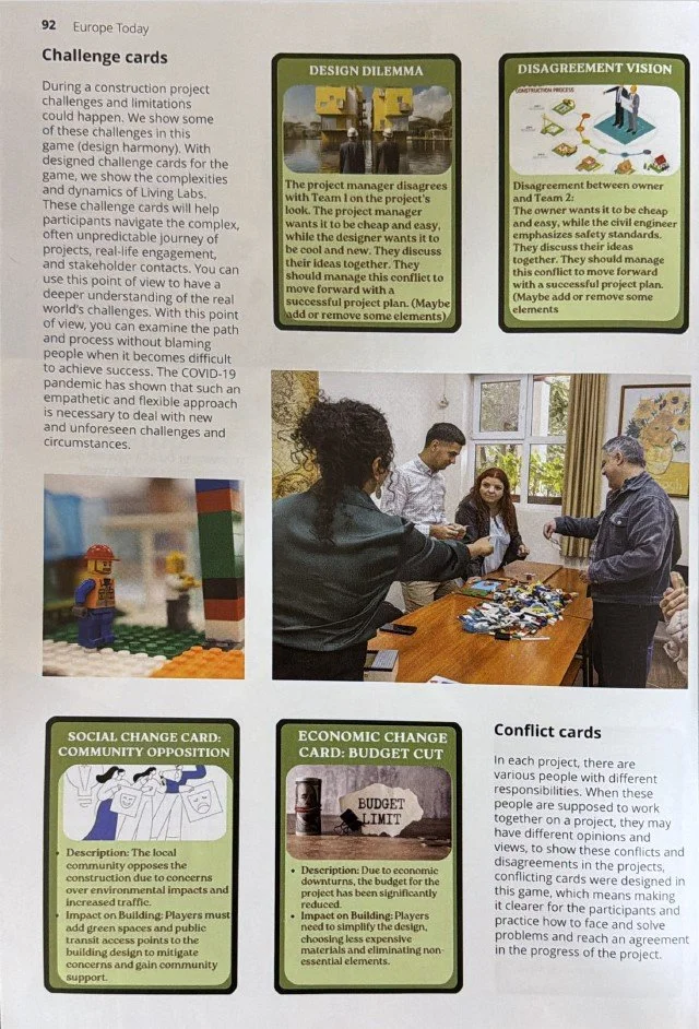
For this special issue, I wrote and illustrated an article, "Design Harmony: Expanding the Do-It-Yourself metaphor with a LEGO-based serious game" (supported by the MSc River Delta Development programme). It introduces a serious game I designed to make the abstract concept of Living Labs tangible.
The game builds on the "Do-It-Yourself" (DIY) metaphor, drawing inspiration from the visual, step-by-step instructions of IKEA furniture, and translates the complexity of a Living Lab into a hands-on construction project using LEGO, role cards, and challenge cards. Players take on different stakeholder roles (owner, project manager, architect, consultant, contractors, civil engineers) and collaborate to design and build a house, while challenge, conflict, and change cards (design dilemmas, community opposition, budget cuts) introduce the real tensions and trade-offs of collaborative projects. The game was tested and refined across three workshops with different participant groups, using surveys and participant feedback to improve each round. The goal: help people grasp abstract ideas, practice negotiation and decision-making, and experience first-hand the complexity and dynamism of working in a Living Lab.
Technical Solutions Delivered
Serious game design: Built an original LEGO-based game, making the Living Lab concept hands-on and playable.
DIY metaphor framework: An approach to structuring complex collaboration into step-by-step play
Role & challenge cards: designed stakeholder roles and cards simulating real-world tensions and decisions.
Illustration & publication: created the visuals and authored the published Europe Today article.